- Trail name
BI HARAN - Activity
Trail-running – also suitable for rambling - Type of trail
A trail-running track entirely within the municipal limits of Barakaldo. It takes in the two valleys occupied by the picturesque rural district of El Regato, which marks its half-way point.
See beautiful landscapes as you cover the tracks, lanes and footpaths. - Technical difficulty rating
Moderate - Fitness rating
Medium - Length
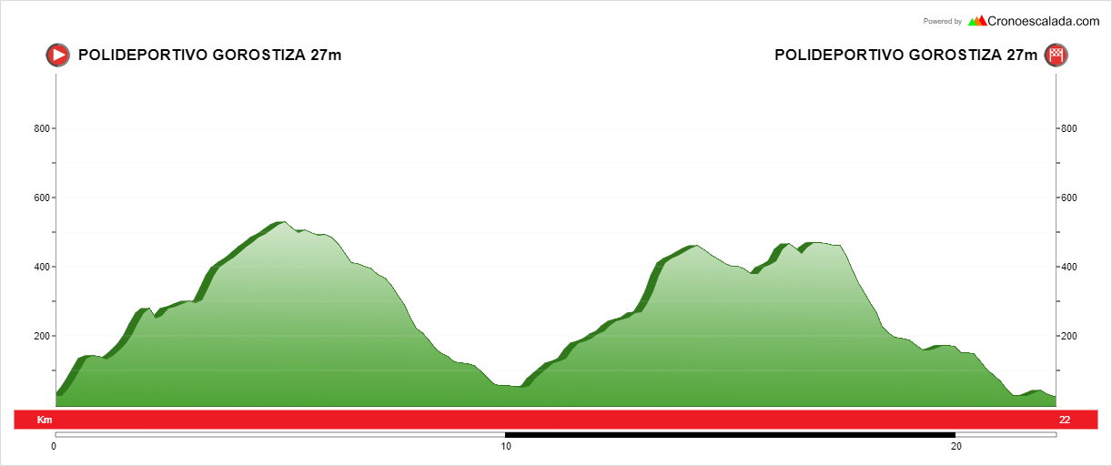
22 km - Altitude gain/loss
1200 m - Estimated completion time
Running: 3 h 30 min. Walking: 7h - Weather & observations
Can be used all year with several variants: the trail can be taken in either direction, or you could start from the half-way point in El Regato and take half the trail back towards the Gorostiza Sports Centre in either direction.
• If you want a more challenging experience, try climbing Mount Ganeroitz 13.5 km into the trail (see description below).
Description & sights of interest
The track starts at the Gorostiza Sports Centre. The sports centre offers visitors parking facilities and changing rooms with showers. There is a kbus stop nearby and a drinking fountain where you can refill your water bottle.
The first climb on the route is up Mount Goronillo, which has an altitude of only 274 m but offers excellent views. At the top, head for the chapel of Santa Lucia (3 km), where you can refill your water bottle again. Then take the track towards the next stopping point. This takes you up Mount Argalario (514 m), where you can enjoy 360º views of the Triano Hills, Greater Bilbao and the El Abra Bay, with the Bay of Biscay as a backdrop. Next, head down towards the El Elegante Cave (8 km). This well-known Barakaldo landmark is reached via various tracks and footpaths. Continue the trail to the River Loiola, which is shallow enough to wade across without difficulty.
At the 10 km mark you will reach the picturesque rural district of El Regato. This is an excellent spot to stop, have a bite to eat and get your strength back in one of the most attractive areas of Barakaldo. It is a real breathing space for the municipality. If you prefer, from here you can turn back towards the starting point via the Gorostiza reservoir, reducing the length of the trail by half. If you decide to keep moving forward you must now climb the other side of the valley, passing an old quarry and the rural district of Tellitu at the 11 km point. This is where the industrial history of Barakaldo was forged. The track climbs to the foot of Mount Ganeroitz (13.5 km) and runs straight on, but if you want an extra challenge you could climb to the hilltop and enjoy the views from the highest point in the municipality. At the 15 km mark, turn off the main track, head up Mount Sasiburu and walk through the crags of Peñas Blancas. At the 17 km mark is Arroletza, where there is a fire-break. From there, head down towards the district of Santa Águeda. This is a historical district renowned throughout the Basque Country for its many long-standing traditions. Rest for a while at the chapel of Santa Águeda, a milestone on the Pilgrim’s Way along the coast to Santiago de Compostela. Then take the road towards the district of Cruces/Gurutzeta, where there are excellent views at the 19.5 km point. There, turn off left down a steep slope back towards Gorostiza and complete the final flat stretch of the trail back to the sports centre.